Atmosphere » Aircraft altitude
AIRCRAFT ALTITUDE
One established method is to use the ambient atmosphere pressure. Although instruments like radio altimeters are used, pressure operated instruments are still made use of.
Small aircrafts fly up to altitudes of about 5000ft although they can fly higher. Larger aircraft can reach heights of 40000ft and helicopters about 10000ft.
Most aircrafts are equipped with Radio Altimeters and Barometric Altimeters that establishes the heights of aircraft above msl, and determines how high an aircraft is compared to another aircraft in its vicinity. Additionally, ATC (Air Traffic Control) will inform each aircraft at what height to fly at so that there are no collisions.
ALTIMETERS
Radio Altimeter: This system sends a radio signal to the ground and receives the echo via aerials on the underside of the aircraft. Distance is calculated by knowing the speed of transmission and the time taken for the signal to return. The range is about 2500ft and it cannot be used above this height. This device can also be used in Autoland systems.
Barometric Altimeter: This is not very accurate in comparison to a RA and pilot has to make several settings during a single flight. The settings depend on where the aircraft is flying and at what altitude. Some are standard and some are obtained from the local ATC.
The settings:
QNE: Instrument set to international ICAO standard of 1013.25mb
QNH: millibar setting given by local ATC.
QFE: Field elevation, setting where the altimeter will read zero when the aircraft lands at the airfield.
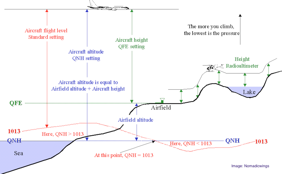
QNH and QFE are taken from local ATC and will vary hourly.
Servo altimeters: these are modernised altimeters indicating systems, which are electrically powered or the altitude data is digital transmitted via a computer (ADC-Air Data Computer).